Navigation & Cartography
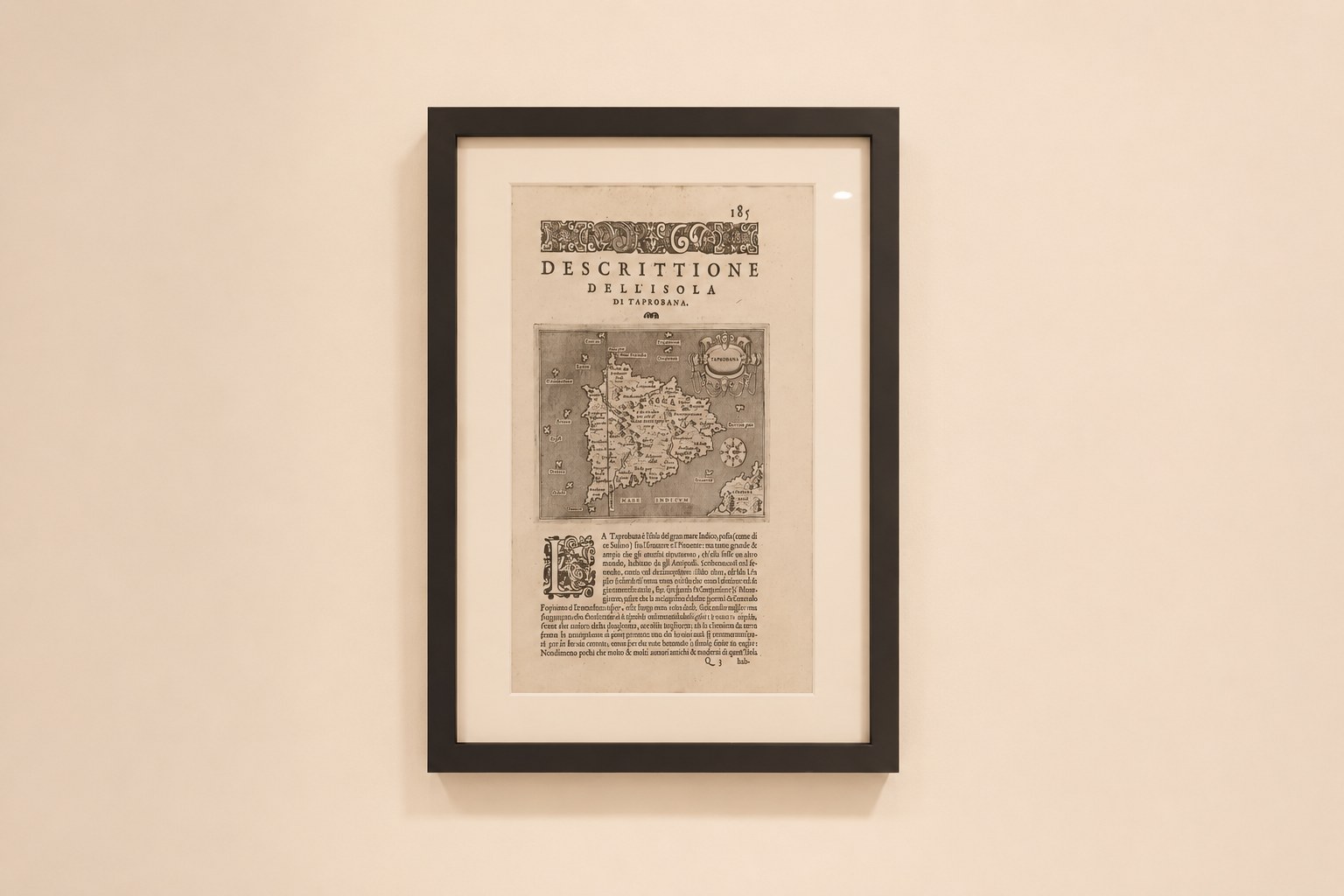
Descrittione dell'Isola Taprobana
A Venetian copperplate map of an island Europe argued over for two thousand years: Taprobana, the dream-version of Sri Lanka, engraved by Girolamo Porro for Porcacchi's island atlas, c.1590.
A Private Archive of Antiques & Historical Objects
Navigation & Cartography
A Venetian copperplate map of an island Europe argued over for two thousand years: Taprobana, the dream-version of Sri Lanka, engraved by Girolamo Porro for Porcacchi's island atlas, c.1590.
For nearly two thousand years, Europe argued about an island it could not find. The Greeks called it Taprobana: a landmass somewhere in the Indian Ocean so vast that some ancients declared it a second world, peopled by races who could not see the North Star. Pliny populated it with one-footed men; medieval travel writers added mountains of gold guarded by man-eating ants. This sheet of laid paper, engraved on copper in Venice around 1590, captures the exact moment that ancient rumour collided with the age of navigation. And, deliciously, it still gets the answer tangled.
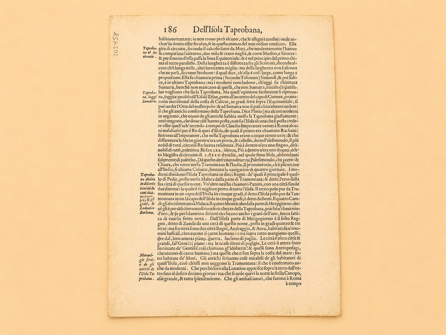
This is an original copperplate-engraved leaf from L'isole più famose del mondo ("The Most Famous Islands of the World") by the Tuscan humanist Tommaso Porcacchi, printed in Venice in the late sixteenth century. The map image measures roughly 20.5 × 29.5 cm, titled in its cartouche DESCRITTIONE DELL'ISOLA DI TAPROBANA, with a sailing ship riding the engraved sea, the signature decoration of the Venetian isolario (island-book) tradition. Held to the light, the laid paper shows the chain lines of the sixteenth-century paper mould. The verso carries Porcacchi's complete Italian essay on the island in period italic type; the signature marks visible on the leaf place it in gathering Q of the volume, consistent with the 1590 edition.
The sheet is conservation-framed under Artglass AR 99 UV-filtering glass meeting the ISO 18902 archival standard, in a fully reversible mount; the leaf can be removed and the verso read without harm.
Porcacchi (c.1530–1585) was a working scholar of the great age of Venetian publishing: an editor, translator, and geographer who produced, in L'isole più famose del mondo (first edition 1572), one of the earliest island atlases to use copperplate engraving rather than woodcut, a leap in precision and elegance. The book was a long-running success, reissued and expanded for over a century. His engraver, Girolamo Porro of Padua, was among the finest Italian copper engravers of his generation, also responsible for illustrating Tasso's Gerusalemme Liberata. Their collaboration, scholar's text and engraver's burin, is what each leaf of the Isole physically embodies.
The name Taprobana descends from Tambapanni, "copper-red earth," the name the Mahavamsa chronicle says Prince Vijaya gave his landing place on Lanka when his followers' hands were stained by the red soil. Greek geographers received the word from afar and never quite recovered: Eratosthenes and Strabo debated its size, Pliny the Elder recorded an embassy from its king to the Emperor Claudius, and also its one-footed Sciapodes, shading themselves with their single giant sole.
By the sixteenth century the question had sharpened into a genuine cartographic controversy: was Taprobana Ceylon or Sumatra? Travellers like Varthema declared for Sumatra; Gastaldi mapped Sumatra as Taprobana in 1556; Münster managed to publish maps supporting both answers. Modern historians, following the Sinhalese chronicles, identify Taprobana with Sri Lanka, but in Porcacchi's Venice the matter was wide open, and Porcacchi himself reportedly apologised to his readers for being unable to settle it.
The confusion is preserved, beautifully, on this very sheet. The map is conventionally catalogued as depicting Ceylon — modern Sri Lanka. Yet the verso essay, citing Solinus, Eratosthenes, and Pliny in proper humanist fashion, goes on to name the island's kingdoms as Pedir, Pacem, Achem, Campar, and Menancabo, which are recognisably the Sumatran sultanates of Pedir, Pasai, Aceh, Kampar, and Minangkabau. One leaf, two islands, eighteen centuries of compounded geography: it is hard to imagine a more vivid physical record of Europe mid-way through working out the shape of the world.
The impression is sharp, clean, and well-inked, with no visible foxing or staining to the map image, an excellent state for a working book-leaf over four centuries old. A signed Certificate of Authenticity confirming it as a genuine sixteenth-century impression is retained with the item. The conservation framing (Artglass AR 99, 99% UV filtration, anti-reflective, archival mount by Framing Centre and Artmill Gallery, Plymouth) is built to museum display standards and is fully reversible, so the Italian text on the back remains accessible.
This is the oldest object in the collection, and it earns the place several times over. It is an authentic product of the golden age of Venetian publishing, from one of the first copper-engraved island atlases ever printed. It is a primary document of one of cartography's great identity puzzles: an island argued over from Alexander's admirals to the Enlightenment. And for a collection curated from Sri Lankan roots, it is something more personal: a picture of the moment Europe was still dreaming the island into shape, copper-red earth rendered in copper-plate ink, the myth and the map not yet pulled apart.
Provenance
Acquired March 2026. Signed Certificate of Authenticity confirming a genuine 16th-century impression retained with the item. Gathering Q signature marks consistent with the 1590 edition. Conservation framed by Framing Centre & Artmill Gallery, Plymouth.